Uttarakhand
The Phulara Ridge trek is one of the lesser explored Himalayan gems concealed within the extensive landscape of the Sankri range. It is a neighbor to the famous Kedarkantha trek and a perfect spot for all trekking enthusiasts looking for something new. Usually, a ridge comes as a part of many high-altitude Himalayan treks, but here it is the show stopper.
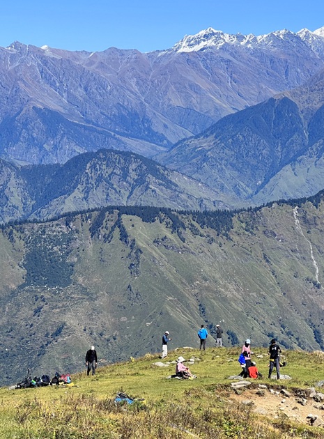
Imagine a heavenly road on the summit point with a view of massive glaciers and peaks on both sides, there is no other ridge as prominent as the Phulara Ridge. Like a miniature version of the Great Wall of China, the Phulara Ridge twists and turns through several valleys and meadows of Uttarakhand. Though the trek allows us to spend more than 4 hours on this heavenly lane, a walk here is timeless and eternal.
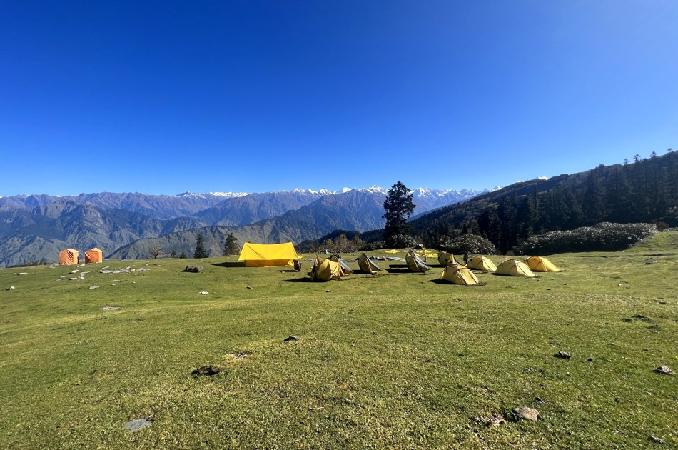
This Himalayan haven is nestled at a height of 3,700M in Sankri, Uttarakhand. It is a 5-day trek with a dose of culture, nature, and adventure, ideal for both beginners and professional trekkers who are looking for a unique experience. In the course of 5 days, the trails of Phulara take us through some dense forest areas with mystical vibes, vast grasslands, and lush green meadows with panoramic vistas. The aftertaste of this place is sure to remind you of the The Jungle Book by Rudyard Kipling.
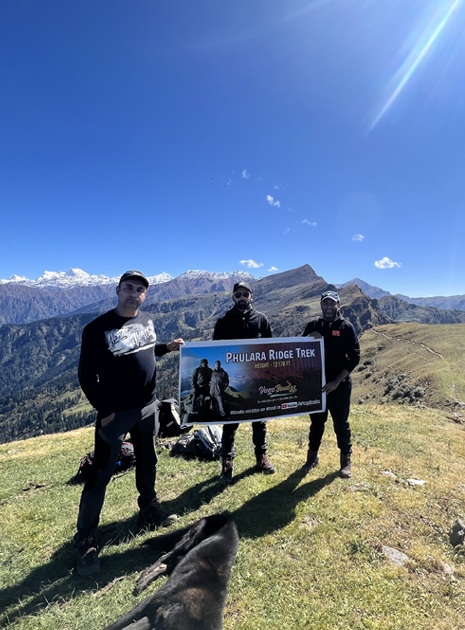
The key highlight of this trek is walking on the ravishing ridge and the stunning views of the massive peaks Swargarohini (6,252M) and Kala Nag (6,387M). Until now, no one has climbed Swargarohini because it’s one of the holy peaks of Uttarakhand. Kala Nag aka Black Peak on the other hand is a renowned peak under the technical expedition category. Other than the ridge and the peaks, walking through the oak and pine trees, relishing the sunset at campsites, spotting wildflowers, crossing through the quaint Taluka village, and relaxing on the vast meadows are some of the other captivating highlights of this trek.
The best time to do this trek is during summers from May to June or before winters from September to October. On us Rating Scale, this trek falls under level 2 – Easy. But, facing high altitudes and trekking for long distances requires adequate fitness levels and proper knowledge about gears. The trail of the Phulara Ridge trek comprises challenging ascents and long distances. Without enough leg strength and lung capacity, you won’t be able to enjoy the trek.
Whether you are an avid trekker in search of a new territory or are only just starting out on your journey into the world of trekking, Phulara Ridge is a trek worthy of consideration. Scroll down for itineraries, images, blogs, and other information.
The journey to Sankri begins from the capital city of Uttarakhand, Dehradun. If you have opted for transportation by us Adventures, please ensure you board your vehicle from ISBT Dehradun latest by 7 AM. If you are traveling on your own to Sankri, the article below could come in handy in planning your trip.
Sankri is located at a distance of 197 km from Dehradun and would take about 9-10 hours to cover, taking us to an altitude of 1,950M. It takes close to 2 hours and 20 km to cross through the city, after which the road starts to gain elevation and reveals a stunning cityscape of Dehradun. About 33 km in, the drive takes us through the spectacular hills of Mussoorie and the renowned Kempty falls. The roads here are long and winding and swift mountain streams run parallel to the roads in many sections.
After crossing Mussoorie, the landscape changes distinctly. Deep gorges are replaced by a canopy of blue pine forests that carry the fresh scent of the woods with the holy Yamuna River accompanying us throughout. Once we cover a distance of 140 km, we enter into a charming little village called Purola, our lunch point. We can wait for a while here and soak in the raw Pahadi (mountain lifestyle) culture and colours. The final stretch of 22 km to Sankri, however, steals the show as we drive through the infamous Govind National Park that is home to a plethora of exotic flora and fauna. The roads can be rough in some sections but the breathtaking views of the dense conifer forests, Tons River Valley and scattered apple orchids more than make up for the bumpy ride.
Expect to reach Sankri by 5 PM. Sankri is a lush green village that hosts some unparalleled views of Mt. Swargarohini, especially during sunset. During the peak winter season, that is December to February, snow starts to make an appearance from the entry of the village itself. We spend the night in homestays.
After check-in, we will be left with enough time to freshen up and explore the surrounding areas.
The gradient for today’s trail is a mix of easy ascents and flat stretches. There are 2-3 water sources on the way as we gain a total of around 700 meters of altitude across 5 km.
We leave the accommodation by 9 AM and walk for a few minutes towards the entry point of the trek. Within a few 100 meters, the roadway ends, giving way to a trail route which takes us through the forest area. As we enter, small shrubs and tall pine trees accompany us on both sides of the trail. About 30 minutes and 1 km in, we are in the middle of a proper jungle with a mix of other trees like deodar, oak, and rhododendrons. Keep your ears sharp, eyes peeled and look up. You can hear and spot some exotic birds on treetops. Now look down, and you will notice squishy moss and brown ferns growing on the sides of small boulders. This setting continues for the next kilometer through a thicker region of the forest.
At the end of 2 km, we arrive at the first dhaba (canteen) of the day. The trail from the dhaba mildly ascends for 1 km and stops at a clearing. The iconic Basuriwala dhaba (flutist’s canteen) is located here. A hot cup of tea and some divine music from the flutist is a delectable delight you can never get in the city.
Beyond the clearing, we enter into the forest area again. The trails mildly ascend for another 1 km and land on a second clearing. Compared to the first grassland, the second clearing is fairly small in diameter. It provides for a good space to rest a while. Half a kilometer from the second clearing, a stunning lake appears in front of us. This is the legendary JKT – Juda Ka Talab. We stop here for lunch near the lake.
JKT – Juda Ka Talab is a famous alpine lake of the Sankri region. Legends believe that the almighty Lord Shiva was looking for a place to meditate. When he entered this clearing, he removed a few strands of hair from his head (juda – strands of hair) and made a divine lake here (talab meaning Lake). To sit next to the emerald green lake and observe the reflection of moving trees and clouds on its surface is surprisingly calming. When the wind brushes the dried leaves, they twirl, swirl, fall on the lake and float around.
JKT is also well known as a campsite for the Kedarkantha trek. The narrow trail that runs right next to the lake will take you to the peak of Kedarkantha. After lunch, we embark on the route opposite the Kedarkantha trail, get into the forest and walk for another 500 meters towards the third and final clearing of the day, our campsite right next to a small water stream.
The gradient for today comprises of moderate ascents and meadow sections. There are adequate water sources throughout the route as we gain an altitude of around 700 meters.
We start at 9 AM and walk through a forest denser than the one we crossed yesterday. Once we cross a distance of 1 km, the flat jungle trails get narrower and start to incline upwards. Here, the roots of the trees protrude from the ground creating a natural facade to welcome you. Don’t try to lean or sit on them, sometimes they are flimsy and weak. You may fall. The trail continues to climb up for the next 500M until it reaches a wide grassland. The open area offers some of the most picturesque views of the Sankri range of mountains with locals going about their daily business.
The nature of the trail changes from this grassland. It starts to descend and leads us back inside the forest area. For 20 minutes and 1 km, the easy descend lands on a charming little bridge. Nimble waters find their way to rush under an old wooden log. We fill our water bottles here and get ready to go through the toughest climb of the day. The trails from the water stream incline at a 45–50 degree ascent for 500 meters. As soon as we climb this patch and reach the top, the tree line ends giving way to a grand skyline with lush meadows.
This podium holds the views of the renowned Kedarkantha peak on one side and the humongous Phulara Ridge on the other. The Kedarkantha trek (3,810M) is a prominent winter trek of the Himalayan region in Uttarakhand, famous for its snowscape and white shades. During the months before winter, the brown and dry shades of this peak overpower the landscape as seen from the trails of the Phulara Ridge trek. The meadows take us up and down through its vast surface and silver-grey boulders. About half an hour from here, we reach Bhoj Gadi, our campsite for the day.
After settling down at the campsite, we rest and go to the top of the ridge for an acclimatization walk. We gain an altitude of 300 meters, spend some time and come back to get our body accustomed to the high altitude.
Today is the main day of the trek. Though the gradient is a mix of flat trails and easy descents, the real challenge for the day is the distance. There is just a single water source on the way, so it is advisable to carry 2 liters of water with you as you start your day.
Around 9 in the morning, we vacate our campsite and start walking along the trail that runs a little lower and parallel to the ridge. These trails are flat for the first kilometer, and then they gradually incline and lead us to the ridge. It is an easy, 50-minute hike. Once on top, brace yourself for some action-packed heavy winds. Hold on to your caps and phone, to keep them from blowing away. The Phulara Ridge is a prodigious architecture of nature. Whichever direction you face, you will be surprised by a wide range of exquisite mountains and deep layers of valleys.
The 360-degree view tends to stay with you throughout your time on the ridge. The pathway takes you up and down, on shrubs with golden brown texture and red crops. As we keep walking further, the heads of many peaks appear in view and reveal their massive body when we get closer to their viewing range. Keep an eye out for the peaks of Swargarohini (6,252M) and Kala Nag (6,387M), enlightening us with their presence. The sheer amount of splendor on this trek is enough to amaze all your senses to the very core.
We continue for 3 km to reach an open plain right next to a water stream, which is our lunch point for the day. We wait for an hour, rest, revitalize and resume our trek. One kilometer into the journey, we reach our descending point. The land from the ridge on the descent point expands and transforms into the beautiful meadows of Pushtara. Walking on these lush green meadows is as easy as a walk in the park - stretch your arms, run and glide like a plane! This is an ideal spot for Frisbee as well.
After descending for 3.5 km on the meadows, we again enter into a dense forest area. The trails starting from the tree line are paved with stones. This is because of the frequent movement of the villagers and shepherds in search of firewood and fodder. The tree line extends for another 1.5 km and takes us to a small clearing next to a river stream, our campsite for the day.
Today’s gradient is composed of easy descents. There are 3-4 water streams on the way.
We start by 9 AM and descend through a dense forest area. The walk downhill is a labyrinth of dead logs intersecting the pathway, with creepers and wild vines growing longer and denser. The fallen tree logs serve as a base for other plants. Don’t forget to check this fallen art.
Another interesting aspect here is the zigzag pattern of the descending trail. If you are in the middle, you can easily notice the first person leading ahead and the last person coming behind. Once we cover a distance of 3 km, we walk out of the forest line and land on a T junction.
The path towards the right takes us on the trail of the famous Har Ki Dun (3,500M) trek and the path to the left takes us to the ancient village, Taluka. We take a left and walk on the antique lanes of Taluka. As we go through the village, we can witness the turquoise blue Supin River from the distance, heritage huts built on wood and sand, native villagers working on fields, and the vibrant colors of their attires. We walk for 1.5 km and finally reach the assembly point at the entrance of the village. The Phulara Ridge trek ends here.
Drive from Taluka to Sankri:
The drive from Taluka to Sankri is a short and exciting experience. A dedicated vehicle picks us up from the assembly point. This bumpy 12 km ride should take us an hour to cover. A peek through the window will give you a glimpse into the depth of the valley. If not butterflies, do not be surprised if you suddenly develop a tingling sensation in your stomach. Be on the lookout for the curious Himalayan ravens checking you out as you drive through the valley. After 6 km, we cross a small water stream. The dramatic effect of the vehicle splashing water as it drives through the stream does its share to induce childlike glee! On reaching Sankri, we rest our weary selves in the warmth of the homestay, hosted by a local family.
We leave Sankri by 9 AM and reach the Dehradun ISBT bus terminus around 8 PM. Because of heavy traffic, the roadways from Sankri to Dehradun are prone to delays. If you are planning to travel by flight, it is advisable to stay for the night and plan your journey the next day.