Uttarakhand
One amongst the many impressive mountains in the Garhwal Himalayas, is Black Peak – the highest peak in the Saraswati Range of mountains in the Ruinsara Valley. Called Kalanag in the local dialect – named so for the uncanny resemblance of the head of the peak to the head of the black cobra – it is 6,287 M of awe-inspiring beauty. The Bandarpunch massif (also called the Saraswati range of mountains) consists of 3 peaks: White Peak or Bandarpunch II at 6,102M, Banderpunch I at 6,316M and Kalanag (Black Peak) at 6,287M. Daunting for its structure and the nature of climbing required to get to its top, Black Peak dominates the Bandarpunch massif bringing it up the ranks on every mountaineer’s list of peaks to scale.
For the magnificent location in which it is housed, Black Peak has some of the most reverential mountains in its vicinity. All the major peaks of the Garhwal range like Swargarohini, Bhagirathi Massif, Bandarpunch, Gangotri range of mountains and many more keep you company along the trail. The trail itself, for passing through Govind National Park which is known for its diverse flora and fauna, boasts of insurmountable beauty across an assortment of landscapes ranging from alpine meadows to pine forests to moraine ridges, boulders and glacial basins.
Black Peak offers the right mix of beauty and challenge. A technical expedition overall, the most demanding section of the climb is the 75 feet vertical ice wall with a 70 degree gradient which comes on your way to the summit. Walking across crevassed snowfields, navigating glaciers, miles of rocky moraines and the continuously thinning air of the altitude, Black Peak is an overall challenging endeavor which requires knowledge of mountaineering equipment and skills specific to surviving at this altitude. Hence, it is an expedition reserved for experienced climbers only. Mountaineering certification or alternatively vast experience in high-altitude trekking and extreme temperature is a mandate to undertake this challenging expedition.
If you have signed up with us for a drive from Dehradun to Sankri, our day starts early. All of us assemble at the meeting point by 7 in the morning so we can start our long drive up to Sankri – a trekking hub in the Garhwal region of Uttarakhand. Although there’s nothing more on the agenda for today other than the 9-hour drive and settling into mountain air, it is better to leave as early as possible for two reasons:
One, so we can reach as early as possible and give our bodies enough rest for what’s coming the next day. And, two, roads on the mountains are unpredictable and it is always better to account for delays when we start. It is also better to reach before it gets dark.
Sankri is a head trail for a lot of trekking routes and is bustling with trekkers across the year. Popular trails such as Har ki Dun, Baraadsar Lake, Bali Pass, Kedarkantha, Dev Kyara, Phulara Ridge to name a few, all start from this little village centered in the background of some of the most splendid mountains in the region.
The drive from Dehradun takes us on scenic mountain roads. If you have the slightest motion sickness, the smooth roads can easily make your head spin with its curves. The ever-changing landscape with each turn, however, is a good way to keep yourself distracted. Tall trees, massive fields and entire mountain faces cut into steps for farming are views you wouldn’t want to miss for some shuteye. The drive takes you through some very big towns but also alternates between small patches of busy roads with village shops and long empty stretches with nothing but the sound of the wind and the birds.
The constant shift between the noise and the calm has a different sense of serenity attached to it. What’s even better is that breakfast and lunch, on local dhabas along the way make sure we get to indulge our tastebuds in some locally popular cuisine. The last two hours of the drive take us through a smooth road lined with thick forests on both sides. The sparkle of the forest is enough to refresh us from the long drive to get to our destination. Sankri is a head trail for a lot of popular treks and hence is not short on facilities. Although there is no phone network in Sankri, you can probably find a shop in the market which will be happy to loan you wi-fi in case of urgent need.
Waiting for us, at the end of the trail of this back-breaking journey will be a warm, wooden homestay with cozy rooms and a home cooked meal. Expect to reach latest by 7 PM.
If you have not opted for travel with us from Dehradun to Sankri and are to meet the group directly at the head trail, check out the article on how to reach Sankri (hyperlink article) for any assistance. Do plan your travel so as to reach Sankri latest by 7 in the evening. (Please note: us can arrange for your transport for an additional cost as mentioned in the Add-Ons section above.)
Today is an early day because there is much ground to cover. We should be done with breakfast anytime between 7-8 AM which gives us enough time to soak in the morning sun and the beauty of this mountain town before we leave for the day by 9 AM.
There is a narrow kaccha road that can be covered on wheels. Do not, however, expect this to be a quick drive – we are likely to encounter JCBs shoving parts of fallen mountain off the narrow roads on multiple patches all through the 12 km stretch. The drive should take anywhere between 2-3 hours based on how many times we have to wait for the road to clear. The waiting does not seem too tiresome for the fresh water streams with fantastical views of the forest and mountains. A deep gorge with a stream(nalla) flowing underneath is invigorating. The nip in the air keeps your senses active and the mind, refreshed.
At the end of the road is a small mountain village named Taluka, bursting with colours. You will know you have reached when you see rows of mules standing obediently in a line, facing the mountain and about a dozen tiny canteens lined up to serve you hot food in case you shall need it before your trek! A lot of popular treks like Har ki Dun and Bali Pass start from here so it is forever bustling with the contagious energy of trekkers.
After breakfast and picking up our packed lunches for the day, we set off towards Seema which is going to be our first campsite on this trek. Although we are not gaining much altitude today (just 160M from Taluka to Seema), the length of the walk is the real challenge. The trek starts on even land with a strong smell of the forest in the air; the lush landscape adorned with waterfalls by a half dozen. The land is mostly even, save the jumping over massive fallen trees and big boulders. The inclines otherwise are gradual with the grayish blue of the boisterous Supin river following alongside as a faithful companion.
After an hour of climb we reach our first clearing out of the forest. You will see two dome-like structures built as a stop-and-rest space to keep you from the harsh sun. Another hour into the trek and the trail opens up on one side to expansive views of the valley. This is when we hit our first patch of steep incline which will take all of 10 mins to cover but is efficient enough to make you stop for a breath or two. The next hour seems like quite a relief, then, for it being a flat land with a few humps along the way. It’s a steady incline from here on. We hit one more food joint one hour away from the campsite – stack up on some energy if the trail’s knocked some air out of you.
The forest floor is wet and mucky and gets slippery. Remember to walk carefully. The shiny dots you see covering the mountain faces on the opposite side are houses of entire villages resting precariously on these rugged slopes. The only traffic jams you are likely to encounter on these routes are cows going about their business for the day as you try to squeeze through the crowds of them on these narrow trails.
Expect to reach the campsite latest by 6 in the evening after a 6 hour trek. The 2 km stretch of the long camping ground has rooms available with views of the mountains, alongside the river, in open ground or tiny patches snuck behind trees away from the crowds. Take your pick of the view you want to pitch your tent and rest your weary self for the night.
Considered sacred by locals in the area, Ruinsara Tal is a high-altitude lake resting its bright blue self at an elevation of 3,500M. The Ruinsara trek is also a popular trail for trekkers visiting the Har ki Doon Valley. Adorned by the bright colours of alpine vegetation, Ruinsara is at a distance of 14 kms from Seema. Legend says that this is the route Pandavs passed by on their way to heaven through the Swargarohini peak which is also visible on the trail. Expect to reach this gorgeous campsite by early evening and rest yourself amidst its beautiful landscape.
As you make your way towards Kyarkoti Base Camp from Ruinsara Tal, you start to see the summit of Black Peak. Kyarkoti is a massive patch of grassland surrounded by boulders and snow-clad mountains. The campsite lies next to a spring. We dare you to stop the adrenaline from rushing through your veins as you get to the base of this mesmerizing peak. Gets a good look at your ultimate goal standing tall right before you, for the first time in the trek!
A lot is to be achieved during your time at base camp- from the distribution and setting up of all the gear to technical training and practice on the icy slopes. But before then, you have the entire day to rest your bodies and acclimatize to the terrain, altitude and temperature of the base camp which lay at 3,820M – a height gain of approximately 2000M from Sankri, the village where it all began!
Since the conditions on high-altitude are unpredictable, there is a constant readjustment of plans to adapt to the situation at the time. Providing fixed day-wise schedules is hence tricky. But roughly, the schedule includes rotation rounds between camps which is a standard acclimatization process on high-altitude expeditions. Black Peak has 3 camps after base camp: Advanced Base Camp (4,600M), Camp 1 (5,100M) and Summit Camp (5,500M).
Given that high-altitude climbs demand a rigorous acclimatization routine, expeditions usually employ the method of making rotation rounds between camps so as to better adapt to the environment. Living the tenet of ‘climb high, sleep low’ which is a golden rule for survival in that altitude, we make multiple rounds between campsites. For Black Peak, specifically, we make two rounds. The first is when we ferry our load up to the next camp, leave our stuff there and then climb back down to the lower campsite to spend the night. The next day, we climb back up to the camp where we left our stuff and proceed to pitch out tents to now occupy the campsite. What this achieves is a three-fold benefit. Firstly, you can divide your weight between two days so as not to carry a massive amount in one trip. Secondly, it introduces the body to a higher altitude environment but gives it time to better adapt to it by not pushing it in this new height giving it a better chance to survive that altitude. Thirdly, for each time that you climb the same route, it tends to get easier and easier, refining your technique, skill and adaptation.
The entire length of the expedition will include proper acclimatization, rotation rounds, rest days and a possibility of 2 summit attempts in case of bad weather.
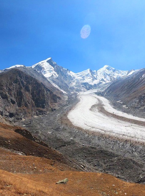
Base Camp (3,820M) to Advanced Base Camp (4600M): It’s a fair bit of altitude gain from Base Camp to Advanced Base Camp but a good trial run to get accustomed to the slopes and terrain of the peak. The trail takes you through grass lands, onto a bouldered section followed by a steep climb through a small patch prone to landslides which will take you into a moraine rich land and then onto a glacier. The climb should take close to 4-5 hours.
Advanced Base Camp (4,600M) to Camp 1 (5,100M): The terrain is similar to the one we ended with yesterday – moraines, glaciers and ice. You will start to realize that everything seems easier the second time around.
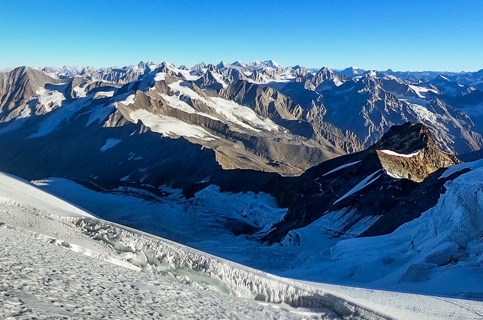
Camp 1 (5,100M) to Summit Camp (5,500M): With a majestic view of Swargarohini to the North and Bandarpooch to the south, we have now reached a terrain rich in hidden and open crevasses. Slowly adapt to the environment, terrain and its challenges to make your way to the top of the peak.
Summit Camp (5,500M) to Summit (6,387M): We push off for the summit in the dead of the night. Hence, one immediate challenge is the night cold and the violent winds of the altitude. The summit climb is fairly challenging and involves navigating vertical ice walls of a gradient between 70-75 degrees with a height of 75-85 feet. These sections will require the use of fixed ropes and jumars to climb until we make it to the ridgeline. As opposed to its brutal slopes, the summit of Black Peak is fairly flat. We aim to reach the very top of this gorgeous peak in 7-8 hours and start our descent soon after so as to make it to the sanctuary of our tents before the snow starts to get unstable. Remember to exercise extreme caution on your way down, for descends are known to be more ruthless than ascends.
With our first summit attempt on Day 10, we aim to reach down to Base Camp by Day 11, Ruinsara Tal by Day 12, Seema by Day 13 so as to drive back to Sankri, our trail head, by Day 14.
Your expedition ends here but not before some celebration. How can we end this adventure without a summit party? Like we indicated before, the weather on high-altitude is unpredictable as are many other conditions. We would suggest you keep spare days between the end of the expedition and your travel arrangements to head back home.
In case of bad weather or other difficulties which might set us off schedule during the course of the entire expedition, Day 16 is set as a reserve day. This will only get used if unexpected and unforeseeable conditions present themselves at the last minute preventing us from reaching our destination as planned.